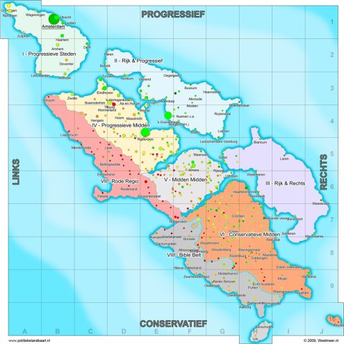
Fantasy political map of the Netherlands
This map shows the fake island kingdom the Netherlands could be if its geography fully followed its politics. In the real world, top left dogs Nijmegen and Groningen are separated by 200 kilometres, as are right wing islands Kessel and Urk.
Here’s a quick legend: links = left, rechts = right, rood = red, rijk = rich, steden = cities, and midden = middle.
The two regions that in reality do exist as geographical areas are the Bible Belt and the Rode Regio, an area that used to have a lot of communists, basically the Groningen country-side.
The map is one of two made by Weetmeer.nl, the other following more classical coastlines.
I can vouch for the position of Nijmegen, having lived there for ten years. Nijmegen’s and Groningen’s progressive and left-wing attitude may at least in part have to do with a large student body, making up ten percent of the population in the case of Nijmegen. Would the Catholic church have thought that when they started their university there in the 1920s as a bulwark against socialist forces?
(Link: Geen commentaar.)


Interesting: Apparently “progressive/right” or “conservative/left” doesn’t exist.
Not very surprising is it to see all university-cities on the top-left island…
@Eric “Interesting: Apparently “progressive/right” or “conservative/left” doesn’t exist.”
Did you fail poli-sci at school, Eric? :)