‘Gay threat’ makes Belgium and Netherlands rethink shared border

A combination of sex and drugs (and possibly rock ‘n’ roll) is forcing two governments to change the border that divides them. The Presqu’ile de l’Islal, a small Belgian peninsula stranded on the Dutch bank of the river Meuse, is to change hands to eliminate a zone that is, to all practical effects, quite literally beyond the law.
Due to its political status, the uninhabited peninsula is off limits to the Dutch police. And because of its geographic isolation, it is out of reach for their Belgian colleagues. These circumstances conspire to make the peninsula a sanctuary for unlicensed sunbathing, loud bacchanalia and unrestricted drug dealing.
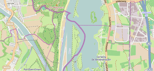
In parts of Limburg the border is formed by the river Meuse. Over time gravel extraction has led the river to change its course, creating tracts of land that the Belgian police can only reach by taking a long detour over Dutch territory. Binnenlands Bestuur explained in 2001: “The peninsulas have become popular as a gay meeting ground. […] In the summer the beach is popular with youths. […] Recently there have been indications that the gays have been bothering the youths. These allegations cannot be verified because the Dutch authorities have no legal status in the area and the Belgian authorities cannot act there because,” and here the author cranks up the dramatic background score to eleven, “they would have to invade our country through the town of Eijsden!”
Oh the horror! The voice of sanity is one Johan Lahaye speaking for the town of Eijsden who told Trouw shortly after: “There is no gay beach there. We’ve had the grand sum of exactly one complaint.” By that time however the Dutch parliament had started to study the issue and the Minister of the Interior had promised to make the border correction a priority. Last year De Limburger reported on a border committee that had visited the area and was ready to send a report to the capitals of both nations.
The border correction is expected to take place in a year or two. Gentlemen, start your engines.
The last time the Netherlands changed its borders was in 2010 when it gained 3 volcanoes (a number which had been 0 since 1945) and its highest point became 887 metres (formerly 323 metres)—three of the Dutch Antilles became a part of the country.
(Map by OpenStreetMap contributors, some rights reserved; the big purple line is the border)

[…] y más info: Strange Maps, 24 Oranges, y periódicos holandeses googletraducidos: 1, 2, […]